
Location: Hunua Ranges
Author: Jack Anderson
Date: 29th June
Last weekend's Mt Pirongia trip was foiled due to Pāhautea hut being fully booked. So I
searched for a plan B and settled on a mission on which I’ve been mulling for months - the
highest point in the Auckland Region, Kohukohunui Peak in the Hunua Ranges, at 688 m! (It’s
technically Hauturu/ Little Barrier at 722 m, but the council keeps this top secret). I recruited
fellow civil engineer Anuraaj and sent the word out just before midnight on Thursday. Man, does
the AUTC mailing list provide - within 24 hours, we had 14 signups!
The initial plan was to depart the clocktower at 8 am, drive up to the northern end of the Upper
Mangatawhiri Dam and hike Ernie’s Track to the summit. Fortunately, Aaron came in clutch and
informed me that this section of the road was gated off. So, the revised plan was to start at the
southern end and begin east, adding about two hours overall and increasing the trip to 22km.
Fortunately, everyone but (surprisingly) the German guy was game for a 7 am start.
So we assembled at the clocktower at 7 am and hit the southern motorway. My car's
conversation primarily consisted of Biden’s winning debate performance and the inevitable
rediscovery that far too many engineers are in the tramping club. After an hour, we reached
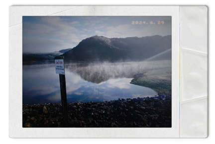
Hunua Regional Park and descended to the reservoir, cloaked in gorgeous sunlit fog. We walked
along the long gravel section (Lilburne Road) to Piggots Campground, offering more views of
the humongous reservoir (the second largest in Auckland at 16.5 million cubic metres).

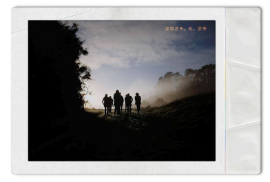

After several gnarly stairs, we continued along the Mangatawhiri Ridge Track to the first dece
lookout. An island could be seen in the distance, which Miles suggested must have been
Australia. The deep insights didn’t stop there. I got to speak with Raphael from Brussels, who
studies bird cognition - and Kayla from New Caledonia, who studies photography and took the
two wicked shots above.

Eventually, we reached the Kohukohunui Trig Track and continued to the Peak at 688 metres. We
climbed up the tower and were treated with views of the Coromandel Peninsula, the Firth of
Thames, the islands of the Hauraki Gulf, and the Waitakere Ranges, which were covered in
approaching rain clouds. On the way back, it started to pack in, but fortunately, everyone brought
raincoats, and the forest canopy absorbed most of the rain. Most of us enjoyed seeing the
Hunuas in their gloomy alter ego. We also managed to spot a Kākā high in a pine tree.

Just as the sun began to set and clouds developed a rosy hue, we returned to the reservoir and
said our goodbyes. Fortunately, the trusty Aqua had no problems getting up the steep gravel
section back to the main road. On the way back to the clocktower, Mimi, Hannah, Anuraaj and I
stopped off at BP for a well-deserved Whittaker’s bar and chai latte. Ngā mihi o Matariki, te tau
hou Māori!


Comentarios